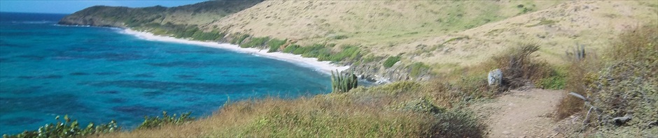
It’s been months (five) since I’ve published anything about hiking on this blog as all my writing time has been focused on my book. It’s not that I’ve quit walking or going on hikes, I have just been spending all my desk time devoted to finishing and publishing my book, “Caribs:The Original Caribbean Pirates & Founding Fathers of American Democracy” which is available in a (Kindle Edition) and (Paperback Edition). Since I can only stand to sit at my desk about five hours a day, I have still been hiking and looking for new historic trails to walk as the Island of St. Croix has 5000 years of Amerindian occupants and over 500 years of European occupants.
One of the more intriguing questions is the location of the “castle” of the French Governor du Bois who ruled from 1659 to until perhaps 1665. If you believe in the fantasies presented in romantic histories, this problem was solved about 50 years ago when the ‘castle’ was located in the heart of an upscale neighborhood called Judith’s Fancy. Florence Lewisohn simply asserted than the mansion was located in Estate Judith’s Fancy and “The ruins of this residence stand today, done in the old French style with a small chateau with two unusual towers at either end, one of which is still there.”
Unfortunately, there are several problems with the Judith’s Fancy location, not the least of which is there is no tower in the vicinity of the ruins. Also, a 1920 report by the USGS places the castle high on a hill (303 foot) instead of the flat lands of Judith’s Fancy. While both sources place the castle to the north of my house, there are no hills in the area with ruins on them and none are above 238 feet.

1671 French Map
Like all good mysteries, I started with an old Map from 1671 and ended with a feeling that I was replaying the spooky ending of the Da Vinci Code including a muscular young guy (bare to the waist) and a couple of unrestrained pit bulls.
The French Map of St. Croix from 1671 is drawn in a manner that South is towards the top of the page. Over the years as ownership changed from French to Danish to American, there have been several changes in name and only those who study history are aware of the old names. The same 1920 inventory of estate names refers to the top of the Hill I live on as Crameni or Soldier Hill. It is now referred to as Judith Hill but that is unnecessary because the map is good enough to place my house on Crameni Hill with Christiansted Harbor (Bassin) to the East, Salt River to the West and Judith Fancy to the North. In this map, the Governor’s castle is shown on a hill almost due South of Crameni.

1958 Topological Map
The next step was to get a copy of the 1958 topology map of St. Croix and check the topology and roads on the hill south of mine now identified as Judith. Indeed, their is a road which takes you to the 300 foot level and it shows houses on that road prior to 1952. Interestingly enough, the road does access Queens Quarter and so I got two friends to take a hike so we could explore any ruins. Before we could reach the end of the road as shown on the map, we found a house built in the middle of the road blocking our path.
And then, we were attacked by two very aggressive pit-bulls. Now I always carry a walking stick and one friend uses “the voice”. I guess these dogs have never heard of Darth Vader because they kept on attacking him. I was able to keep the one dog at bay with my walking stick but that only made it worse for my friend as both dogs went after the guy who relies on his voice to tell the dogs to go home.

Pit Bulls Ready to Attack
After the dogs had backed us 50 feet down the street, a young man came out of his house wearing only shorts and attempted to call the dogs back. They ignored their master until they backed us another 50 feet down the road. Once he had the dogs under control, I asked him if I could take a picture of Christiansted Harbor from the public road. He answered his father doesn’t like that and the dogs were not yet completely under his control so I missed a very scenic shot.
Now this would be the end of the story if Google Earth did not exist but I decided to go back for another look or to to see if there were any ruins on the hillside. The shot below shows a ruin over the word Navy at the bottom (center) which when you look due north points to my house on the opposite hill.
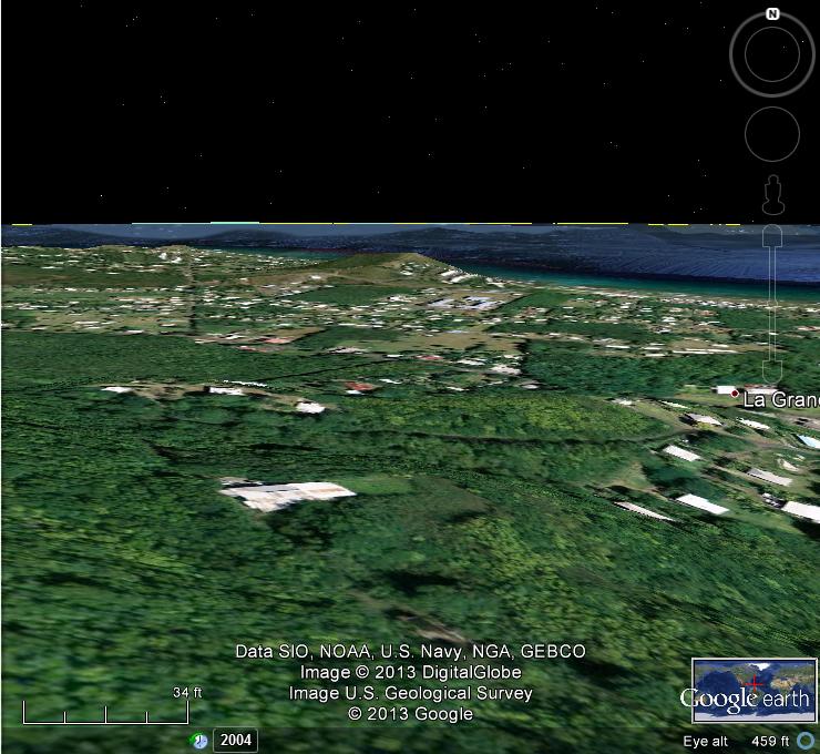
View North From Ruins
The final picture is as close as I can get on Google Earth without breaking up and shows an exceptionally large house on what appears to be an artificial plateau. The house appears to block the historic road and access to the ruins. The plateau is clearly visible on the 1958 topology map.

Close up of Ruins
The interesting aspect about the ruins is on the east side where there is a circular base for a tower. It is unlikely this is a windmill as it is down hill from the square building and all windmills were built uphill from the factory with the cane juice running downhill. One possible explanation is that this is a “small chateau with [one] unusual tower” and is the Governor’s Castle.
Now whether this is the Governor’s Castle from the Knights of Malta Era or not should not be the message of this post. When walking in areas new to you, you should be aware of all Safety issues. The biggest ones in St. Croix not only includes dog attack, but there are issues with insect bites, dehydration, toxic plants, lack of cell phone coverage in some areas and no easy way out if you have problems. Most of our older hiking guides have the experience to keep you out of harms way.


Hi John, I have traced my ancestry as far back as Governor Francois Du Bois and I found your blog very interesting. My ancestors descend from his third and last marriage to Elisabeth de LA Guarigue on the Isle of St Croix. I was wondering if you are aware of any paintings of him in the museums or library in St Croix?
Loretta, as you probably know Governor Francois DuBois was quite an incredible man who almost succeeded in making St. Croix the most prosperous French Colony by the simple expedient of turning it into a free port and doing extensive trade with the Dutch. Low prices and abundant trade goods made it the destination of choice for French colonists. He lost to French politics. To track a portrait, you would have to seek the archives of St. Kitts, Haiti or New Orleans. He died in 1674 and if his wife was looking for an easier life she might have gone back to St. Kitts. If she stayed, she would have been forced to move to Haiti in 1695 and one son is know to have been on that island after the french moved everybody from St. Croix to Haiti in that year. If a portrait made it to Haiti, it may have ended up in New Orleans after the slave revolution of 1803. In my new book on the Lost Pirate Treasures of St. Croix, I discuss his economic policy as it relates to piracy prior to the golden age. From his knowledge of Business and Trade, I would be tempted to classify him as a Huguenot which group worked well with the Knights of Malta. Relying on a Catholic sources of the era, Arnold Highfield in his new book, Sainte Croix, 1650-1733, makes him out as a child of nobility and traces him back a couple more generations. Have fun figuring this all out. By the way, Arnold and I both place his Mansion on a ridge on La Grande Princess and not in Judith’s Fancy.
Does the 1920 USGS report place du Bois castle to the north (?) of your house, or to the south of your house? Your research shows your house north of the ruins.
Have you visited the site yet? What does it look like? A castle? Or something else?
Best–Evan
The 1920 USGS is ciontradictory as to location placing it both in Judiths Fancy and at the 238 foot level in Queens Quarter. Arnold Highfields new book places it on the ridge at Le Grande Princes, slightly to the south of where I place it in an area where there are no obvious ruins. No I have not yet explored this area because of the issue of access.
Will be down in St Croix Feb 15. Who owns the property? What is the street address? Can you see the ruin from the street below? Pls email me with your phone #, and I’ll give you a call. Evan
Hi Evan, We still don’t have street addresses in paradise so not sure who owns it. A relator could probably track it for you. For now it appears landlocked because the house with the pit bull blocks the historic road. The topo map I used is easy to find. Google Univ of Texas Topological Map of the Virgin Islands. They have maps of Christiansted for 1958 and 1982, Find Judith’s Hill by salt river follow a line south until it intersects the road going southwest from La Grande Princess.
My phone number is 340-277-3737. Give a call so we can hook up.
John
OK–left you a message. Will try again. Evan
Pingback: The Diggers come looking for the Ark of St. Croix | Hike St. Croix
Do you mind if I quote a few of your posts as long as I provide credit and sources back
to your weblog? My website is in the exact same area of interest as yours and my visitors
would certainly benefit from some of the information you provide here.
Please let me know if this alright with you. Regards!
No problem quoting or linking. Sorry I didn’t respond right away.
I live on St. John, and also love hiking and exploring old ruins. I would like to read the book, “Ark of St. Croix” before my next trip to St. Croix but I cannot find where to buy it online. Please send me a link to kpatrie@balancewalking.com Thank You!
No problem quoting or linking. Sorry I didn’t respond right away.
I would also – I bought your book Pirate Treasures of St Croix and my first grader and I read it as his bedtime story!
Thanks for the compliment. Most Pirate Treasure has been lost at sea, but as I described, you can get a metal Deccan and start searching for land based treasure on St. Croix.